
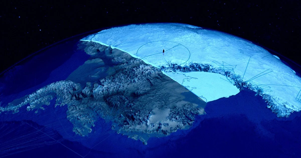
A deeper Antarctic “gravity hole” and what it signals about Earth’s hidden machinery
A new high-resolution gravity map of Antarctica, produced by researchers at the University of Florida and the Paris Institute of Earth Physics, is drawing attention not because it offers a dramatic surface discovery, but because it sharpens our view of what lies beneath the continent’s ice—and how those deep structures may evolve over tens of millions of years. The team reports that a vast low-gravity region—often described as a “gravity hole”—has deepened over roughly 70 million years, reflecting long-term changes in subsurface mass distribution and rock flow.
The methodological leap is as consequential as the finding. By using seismic waves from global earthquakes as a kind of planetary CT scan, the researchers reconstructed how material in Earth’s interior has shifted under Antarctica. Their models point to rock flow patterns influenced by Earth’s rotation, suggesting that the gravity anomaly is not a static curiosity but a dynamic feature shaped by mantle-scale processes.
Importantly, the study aligns the intensification of this low-gravity zone with major Earth-system transitions: the onset of extensive Antarctic glaciation, large sea-level swings, and changes in ocean acidity. The work stops short of claiming direct causality between deep-Earth dynamics and surface climate outcomes—an appropriate scientific restraint—but it strengthens a growing idea in geophysics: that ice-sheet stability and climate evolution may be partly conditioned by processes far below the crust, not only by atmospheric and oceanic forcing.
Seismic “CT scans,” satellite gravimetry, and the rise of Earth digital twins
From a business-and-technology perspective, this research is a case study in how computational geoscience is changing what can be measured—and therefore what can be modeled, financed, insured, and regulated. The use of earthquake-generated seismic waves as an imaging tool underscores the maturation of:
- High-performance computing (HPC) capable of running inversion models at scale
- Advanced seismic tomography methods that convert wave travel times into 3D interior structure
- Machine-learning–assisted signal processing that improves detection and reduces noise in complex datasets
Just as medical imaging transformed diagnostics by making the invisible legible, seismic-CT approaches are enabling a new generation of Earth “digital twins”—simulation environments that can test hypotheses about mantle flow, crustal deformation, and long-horizon geodynamics. For climate science, the near-term value lies in better boundary conditions: gravity anomalies can refine assumptions about subglacial geology, heat flow, and basal conditions that influence how ice sheets move and melt.
Equally notable is the emerging multi-modal observation stack. The study’s logic sits naturally alongside satellite gravimetry missions such as GRACE-FO, which track changes in Earth’s gravity field over time. When seismic imaging, satellite gravimetry, and on-ice sensor networks are fused, uncertainty narrows—creating the possibility of more responsive monitoring of geophysical anomalies that matter for both science and operations.
For AI and LLM-driven analytics, this is also a data architecture story: integrating seismic, gravimetric, and paleoclimate reconstructions expands the “feature space” available to global circulation models (GCMs) and ice-sheet models. That can translate into improved scenario planning for governments and enterprises exposed to sea-level and polar-risk pathways.
Commercial and financial implications: exploration, shipping, and climate-risk pricing
While Antarctica is governed by strict international frameworks, the techniques demonstrated here are broadly transferable—and that is where the economic implications become tangible. High-resolution gravitational mapping and seismic tomography can materially improve subsurface characterization, with downstream effects across multiple sectors:
- Resource exploration and extraction: Better gravity and density models can reduce exploration risk for hydrocarbons and, increasingly, critical minerals (including inputs to batteries and advanced manufacturing). Even where extraction is constrained, the technology improves global prospecting workflows and capital allocation discipline.
- Maritime logistics and polar operations: As firms and governments attempt to anticipate the stability of ice and the evolution of Southern Ocean conditions, improved ice-sheet modeling can influence route planning, fleet investment in polar-class vessels, and insurance pricing for high-latitude operations.
- Climate-risk financing and insurance: Reinsurers and asset managers are under pressure to quantify tail risks tied to sea-level rise, ice-sheet instability, and correlated supply-chain shocks. Incorporating deep-Earth variables into catastrophe and stress-testing models may not change near-term underwriting overnight, but it can sharpen long-duration risk curves—especially for coastal infrastructure, ports, and sovereign risk assessments.
This is where the gravity-hole narrative becomes more than a geophysical headline. If deep-Earth dynamics can be shown to modulate ice-sheet behavior—even indirectly—then long-horizon climate risk may have additional structural drivers that today’s financial models only partially capture.
Governance, security, and the next wave of standards for polar data
Antarctica is not only a scientific frontier; it is also a governance testbed. Findings that connect subglacial processes to surface ecosystems and ocean conditions can be expected to enter policy debates around environmental protection, monitoring obligations, and permissible activity in and around the continent.
Several strategic considerations stand out:
- Dual-use sensitivities: High-resolution gravity and subsurface models can have implications for navigation and under-ice operations, raising the likelihood of tighter coordination between civilian research and national security stakeholders.
- Antarctic Treaty dynamics: As scientific understanding deepens, pressure may grow for stronger safeguards against activities perceived as destabilizing—whether related to resource prospecting, deep-sea impacts, or infrastructure expansion.
- Energy transition and carbon management: Techniques that improve understanding of rock properties and subsurface fluid pathways can support verification regimes for carbon capture, utilization, and storage (CCUS)—a domain where measurement, monitoring, and reporting standards are becoming central to project finance and ESG credibility.
The most consequential takeaway is not that a gravity anomaly exists, but that Earth’s deep interior is becoming measurable in ways that can be operationalized—through better models, better risk pricing, and better governance. As seismic-CT imaging, satellite gravimetry, and AI-enabled inversion converge, Antarctica’s “gravity hole” may prove less like an isolated mystery and more like a signal flare for the next era of integrated Earth intelligence.

 By
By
 By
By
 By
By
 By
By
 By
By
 By
By