


When a Greenlandic Lake Disappears: Rethinking Risk in the Age of Satellite Eyes
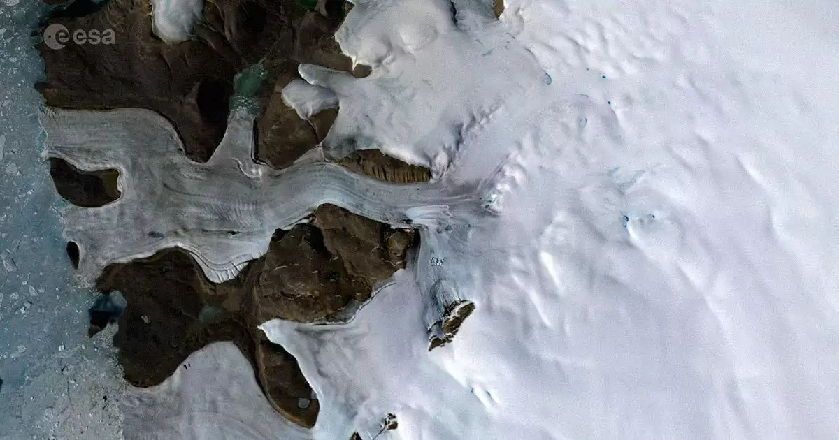
In the summer of 2014, beneath Greenland’s ancient ice, a hidden drama unfolded. A subglacial lake—previously undetected, its existence inferred only by the faintest of geophysical whispers—suddenly ruptured. Over the course of ten days, some 23 billion gallons of water surged through nearly a mile of ice, carving a 278-foot-deep crater into the surface above. This was not merely a marvel of nature; it was a revelation that upended decades of glaciological orthodoxy and sent ripples through the worlds of finance, insurance, logistics, and technology.
Published in *Nature Geoscience*, this study, powered by high-resolution data from NASA and ESA satellites, marks the first confirmed documentation of such an event in Greenland. Its implications reach far beyond the polar research community, challenging how we model risk, price capital, and even imagine the future of Earth observation.
Catastrophic Drainage and the Rise of Cryospheric Digital Twins
For years, the prevailing wisdom held that subglacial water in Greenland moved slowly, its flow dampened by the immense pressure of the overlying ice. The 2014 event shattered this assumption. Satellite altimetry, radar interferometry, and optical imagery—once siloed in separate scientific domains—were fused in a multi-constellation analytic pipeline, reconstructing the event in three dimensions with unprecedented clarity.
The resulting data revealed a violent, nonlinear hydrodynamic process. Water, once trapped, found a pathway through the ice, destabilizing the sheet far inland and accelerating its march toward the sea. This finding is not just a scientific curiosity; it is a harbinger of faster-than-expected sea-level rise, with the potential to redraw coastlines and recalibrate the calculus of risk for entire industries.
What enabled this breakthrough? The marriage of cloud-hosted analytics and satellite constellations—ICESat-2, CryoSat-2, Sentinel-1 and -2—heralds the commercial readiness of “digital twin” ice sheets. These virtual replicas, updated in near real-time, promise a new era of high-fidelity cryospheric monitoring, transforming how businesses and governments perceive and manage physical climate risk.
Capital Markets, Insurance, and the Arctic’s New Strategic Equation
The reverberations of Greenland’s subglacial drama are already being felt in the corridors of capital. For bond markets, the prospect of nonlinear, catastrophic melt events means that tail-risk scenarios for sea-level rise—once reserved for the distant year 2100—must now be considered on mid-century timelines. Sovereign debt, municipal credit ratings, and the insurance industry’s modeled loss thresholds are all being repriced in real time.
Institutional investors, increasingly reliant on Climate Value-at-Risk (VaR) models, face a new imperative: integrate the possibility of abrupt, unpredictable melt events into their probability distributions. For insurers and reinsurers, the stakes are equally high. Parametric insurance products, triggered by satellite data, are gaining traction, while regulators push for tighter capital adequacy to internalize the uncertainties of a destabilizing cryosphere.
Meanwhile, the Arctic’s rapidly changing landscape is rewriting the rules of global trade. Longer navigable seasons along the Northern Sea Route could slash Asia-Europe transit times by 40 percent, but these opportunities come with heightened search-and-rescue costs and new geopolitical frictions. For miners and energy companies, sub-ice hydrodynamics now influence exploration permits and ESG risk assessments, forcing a demand for granular, real-time data before capital is deployed.
The Space-for-Climate Nexus: Data, Disclosure, and Opportunity
This episode is also a clarion call for the space-based Earth observation industry. The ability to validate and reconstruct such events underscores the strategic value of commercial satellite operators. Mergers and acquisitions between traditional EO vendors and analytics-as-a-service startups are accelerating, as the market for subscription-based climate intelligence matures.
Regulatory regimes—ISSB, SEC, EU CSRD—are raising the bar for physical-risk disclosure, making high-frequency, high-resolution cryosphere data not just a competitive advantage, but a compliance necessity. State-sponsored Arctic strategies, from China’s “Polar Silk Road” to Russia’s NSR tariffs, now hinge on updated ice-thickness forecasts, further entwining geopolitics with geospatial intelligence.
Venture capital, sensing the tectonic shift, is pouring into early-stage EO companies—over $2.7 billion in 2023 alone—fueling a race to deliver AI-driven hydrological nowcasting and digital-twin–enabled risk management. For corporates, the message is clear: invest in dynamic cryosphere datasets, integrate them into facilities management, and build cross-disciplinary teams that can recalibrate scenario planning in the face of nonlinear risk.
The Greenlandic drainage event is not an isolated anomaly, nor is it merely a footnote in the annals of glaciology. It is a signal—subtle, yet seismic—that the era of slow, predictable climate change is over. Those who embrace satellite-driven climate intelligence, who internalize the lessons of a rapidly changing cryosphere, will be best positioned to navigate the converging challenges of physical risk, regulatory scrutiny, and emergent market opportunity. In this new regime, the capacity to see—and act on—the invisible may prove the ultimate competitive advantage.
 By
By
 By
By
 By
By
 By
By
 By
By

 By
By