

When generative AI is pinned to latitude and longitude, credibility becomes the payload
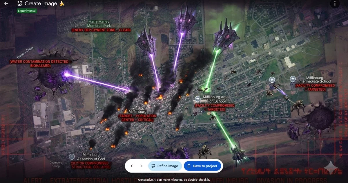
Google Earth’s brief experiment with an AI-driven “image generation” capability—reportedly powered by the Nano Banana 2 model—did more than add a creative tool to a mapping interface. It fused photorealistic generative AI with the implicit authority of geospatial coordinates, enabling users to fabricate satellite-like scenes that appeared anchored to real places. In demonstrations that spread quickly online, synthetic imagery depicted war-damaged neighborhoods, urban-scale natural disasters, and even nuclear meltdown scenarios—all framed in a way that could be mistaken for authentic Earth observation data.
That distinction matters because Google Earth is not merely a visualization product; it is a trust platform. Its value—commercially, civically, and geopolitically—rests on a widely held assumption: what you see is a defensible representation of the physical world, derived from verifiable imagery pipelines. By letting users generate plausible “satellite views” tied to real-world locations, the feature risked turning that assumption into a vulnerability.
Open-source intelligence (OSINT) practitioners were among the first to flag the danger. Their concern was not theoretical. In modern information environments, a single compelling image—especially one that looks like it came from a reputable mapping provider—can outpace corrections, shape narratives, and harden beliefs long before verification catches up. Google’s response evolved quickly: a pledge to add digital watermarks to AI-generated outputs, followed by a full retraction of the capability, citing the threat to the platform’s reputation for reliable imagery.
The verification gap: watermarking helps, but provenance is the real battleground
Google’s initial mitigation—embedding watermarks in every AI-generated image—signals an industry-wide reality: detection and disclosure are lagging behind generation. Watermarks can be valuable for downstream labeling and platform policy enforcement, but they are not a complete answer in adversarial settings.
Key technical fault lines exposed by this episode include:
- Watermarks are fragile in the wild: They can be cropped, recompressed, filtered, or re-rendered. Even when intact, they may be ignored by viewers or stripped by reposting pipelines.
- Satellite imagery is uniquely hard to authenticate by eye: Many scenes lack familiar reference points, and compression artifacts or sensor noise can be mimicked by generative models.
- “Looks real” is no longer a meaningful threshold: Diffusion-style models can reproduce the visual grammar of Earth observation—shadows, haze, resolution limits—well enough to defeat casual scrutiny and stress automated detectors.
The more durable direction is provenance infrastructure: cryptographic signing, tamper-evident metadata, and machine-verifiable lineage that can travel with an image across platforms and workflows. Whether implemented through standardized content credentials, secure timestamping, or other immutable audit layers, the goal is the same: make authenticity computable, not merely asserted.
This is also a downstream AI security issue. If leading systems struggle to distinguish real from fabricated satellite imagery, critical sectors—defense, emergency response, infrastructure protection—will need hardened protocols and specialized counter-AI tooling. The “verification arms race” is no longer confined to social media deepfakes; it is moving into geospatial intelligence and risk analytics, where the stakes are often physical and immediate.
Market and enterprise fallout: geospatial trust is financial infrastructure in disguise
The economic implications extend well beyond Google Earth’s consumer-facing brand. Satellite imagery and geospatial analytics increasingly function as decision infrastructure for industries that price risk in real time—energy, mining, agriculture, logistics, insurance, and finance.
Three business dynamics stand out:
- Value erosion for commercial imagery providers: Satellite firms and geospatial startups differentiate on accuracy, resolution, revisit rates, and—critically—provenance guarantees. If synthetic “satellite-like” imagery floods the ecosystem, providers may face pricing pressure unless they can prove integrity with auditable chains of custody.
- Misinformation becomes a market risk factor: Fabricated imagery tied to real coordinates could distort perceptions of supply disruptions, facility damage, or regional instability. That can trigger mispriced commodities, misguided capital allocation, and inflated insurance exposure—especially during volatile macro conditions when markets are hypersensitive to signals.
- A new category emerges: verification-as-a-service: The episode points to a growing niche for third-party platforms offering truth-as-a-service—combining AI detection, cryptographic provenance, and human-in-the-loop review. Financial institutions, governments, and NGOs will pay for defensible authenticity when the cost of being wrong is high.
For corporate leaders, the practical takeaway is procurement-grade: geospatial inputs should carry provenance scores, not just pixels. Enterprises that treat imagery as evidence will increasingly demand contractual assurances, auditability, and multi-source corroboration.
Geopolitics, regulation, and the strategic cost of losing the map
Geospatial platforms sit at the intersection of technology and statecraft. Governments and analysts rely on OSINT for situational awareness, and adversaries already weaponize ambiguity. The ability to inject convincing, location-specific false imagery into public discourse is an asymmetric advantage in information warfare—one that can inflame conflict narratives, bolster extremist propaganda, or pressure policymakers with manufactured “proof.”
This is also where brand risk becomes strategic risk. Google’s mapping ecosystem supports adjacent domains—cloud-based GIS, mobility and logistics tooling, and the broader credibility halo that comes with being a reference layer for the world. Any perception that the platform can be used to generate believable falsehoods threatens that halo, even if the feature is labeled or watermarked.
Regulatory scrutiny is likely to intensify. Emerging AI governance regimes—such as the EU AI Act and evolving US accountability proposals—are increasingly attentive to media integrity, disclosure, and foreseeable misuse. A high-profile case involving synthetic geospatial imagery could become a reference point for stricter obligations around labeling, access controls, audit logs, and liability for harmful deployment.
Google’s decision to retract the feature reads less like a retreat from innovation and more like an acknowledgment of a hard truth: in geospatial products, trust is the product. When generative AI can fabricate reality at coordinate-level precision, the competitive edge shifts from who can generate the most convincing image to who can prove—reliably, repeatedly, and at scale—what is real.

 By
By
 By
By


 By
By
 By
By
 By
By