
A Martian “pyramid” and the recurring economics of planetary spectacle
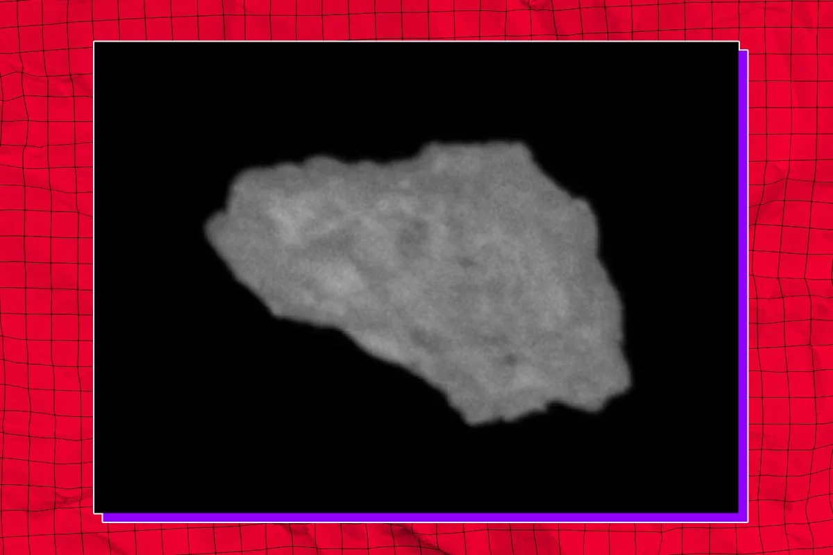
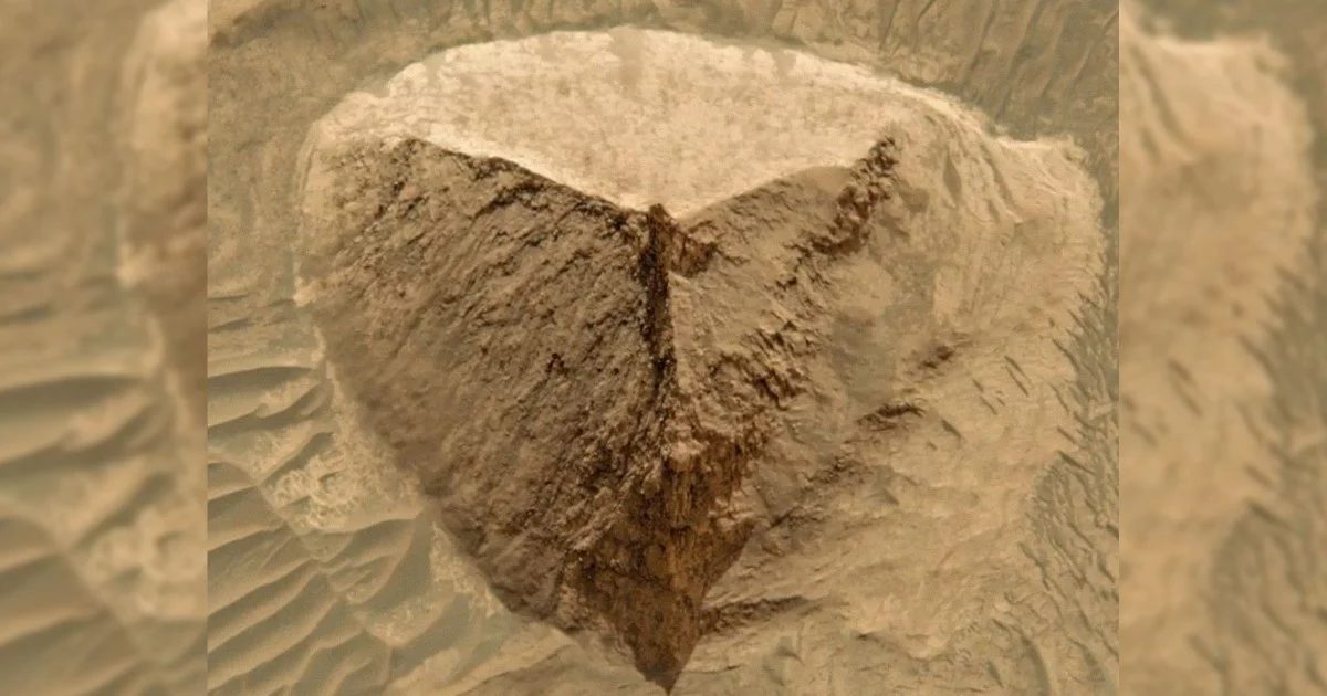
A three-sided, pyramid-like formation spotted in NASA’s 2001 Mars Global Surveyor imagery of Candor Chasma has again ignited a familiar cycle: viral claims of ancient alien engineering followed by methodical geologic explanation. The comparison to Egypt’s Great Pyramid is rhetorically powerful—simple geometry, evocative symmetry, and the human tendency to see intention in patterns. Yet planetary scientists, including Mars Institute chair Pascal Lee, point to a far more terrestrial mechanism: aeolian erosion sculpting layered sedimentary rock, consistent with the broader geology of Valles Marineris.
This tension is not merely cultural theater. It has practical consequences for how space data is interpreted, how public trust is built, and how budgets and business models evolve around planetary exploration. Episodes like the “Face on Mars” and more recent “doorway” features demonstrate that pareidolia—the brain’s propensity to perceive meaningful shapes—can become a market-moving narrative when amplified by social platforms and algorithmic feeds.
For business and technology leaders, the key insight is that the “pyramid” story is less about extraterrestrial architecture and more about information architecture: how imagery becomes belief, how belief becomes attention, and how attention can influence funding, investment, and strategic priorities.
Remote sensing meets AI: higher resolution, higher stakes for interpretation
The controversy underscores a paradox of modern Earth and planetary observation: as imagery gets sharper, misinterpretation can scale faster. Mars Global Surveyor delivered striking detail for its era; later instruments such as HiRISE on Mars Reconnaissance Orbiter pushed resolution to roughly 25 cm per pixel, enabling far more precise geomorphological assessment. But higher spatial resolution alone does not guarantee clarity. Without context—illumination geometry, slope models, multispectral signatures, and comparative geology—high-definition images can still invite overconfident conclusions.
This is where AI enters the narrative. Machine learning is increasingly used to mine massive planetary archives for anomalies, patterns, and candidate sites. That capability is strategically valuable, but it also introduces a new failure mode: algorithmic pareidolia. If training data and validation pipelines are weak, computer vision systems can elevate “interesting shapes” into false discovery cascades—especially when novelty is rewarded over verification.
Key technical implications emerging from this episode include:
- Resolution is not ground truth: Pixel detail must be paired with spectral data, terrain models, and geologic context to distinguish erosional landforms from artifacts.
- Explainable AI becomes mission-critical: Anomaly detection systems need confidence scoring, interpretable features, and audit trails that allow experts to reproduce and challenge results.
- Democratized data requires curated metadata: Open archives are a scientific triumph, but they are most resilient when raw imagery is accompanied by peer-reviewed annotations, uncertainty ranges, and links to comparative formations.
The “pyramid” discourse is therefore a case study in the next phase of remote sensing: not just collecting images, but building trustworthy interpretation stacks that can withstand viral distortion.
Capital, credibility, and the budgetary feedback loop in space science
Public fascination can be a double-edged instrument for planetary science funding. High-visibility claims—especially those framed as “suppressed discoveries”—can temporarily boost attention and energize constituencies that support exploration. But repeated debunking can also seed cynicism: if the public perceives space spending as adjacent to sensationalism, confidence in legitimate research can erode.
That dynamic matters because NASA and partner agencies operate within political and fiscal ecosystems where narrative often competes with nuance. The risk is not that a single viral image changes appropriations, but that the broader information environment shifts the perceived value of foundational work—such as stratigraphy, subsurface radar, atmospheric studies, and sample analysis—relative to headline-friendly spectacle.
Commercial actors are watching closely. The same remote-sensing techniques used to interpret Martian geology also underpin Earth observation, climate analytics, and mineral exploration. Yet investor appetite can be sensitive to reputational volatility. A misinformation-driven spike may briefly lift interest in geospatial startups, but long-term value accrues to firms that can demonstrate verification discipline and defensible analytics.
Strategic considerations for executives and investors include:
- Reputational risk is now a technical risk: Data products tied to sensational narratives may face higher scrutiny from customers, regulators, and insurers.
- Verification costs will rise: Underwriters and institutional buyers may increasingly demand evidence-based methodologies, not just compelling visuals.
- Soft power incentives can distort priorities: Nations and agencies may feel pressure to pursue “public imagination” missions, potentially diverting attention from less glamorous but higher-yield science.
In this light, the Candor Chasma “pyramid” is a reminder that space is not only a frontier of exploration—it is a frontier of attention economics.
From viral anomalies to durable infrastructure for truth in planetary data
The most constructive outcome of this episode would be institutional learning: building systems that preserve public wonder while strengthening epistemic rigor. Citizen science and crowdsourcing platforms have proven their value, but they work best with tiered validation, expert moderation, and transparent uncertainty. The goal is not to suppress unconventional hypotheses; it is to ensure that claims travel with the evidentiary context required to evaluate them.
Several forward-looking moves stand out across policy, technology, and industry coordination:
- Hybrid discovery pipelines that combine machine-learning alerts with geoscientist workflows, producing probabilistic assessments of natural versus artificial origin.
- Cross-sector rapid-response panels—space agencies, universities, commercial imagery firms, and responsible media—capable of contextualizing viral claims quickly and credibly.
- Standards for interpretive overlays on public imagery releases, potentially guided by international scientific bodies, to reduce ambiguity exploited by disinformation networks.
- Ground-truth calibration through in-situ missions and sample analysis, strengthening the interpretive bridge between orbital imagery and physical geology.
The deeper story behind the “three-sided pyramid” is not whether Mars hides monuments; it is whether the space sector can scale a modern doctrine of credibility—where open data, advanced AI, and public participation reinforce scientific integrity rather than compete with it.

 By
By
 By
By
 By
By


 By
By
 By
By
 By
By