

A honeycomb signature at Mount Sharp—and why it matters now
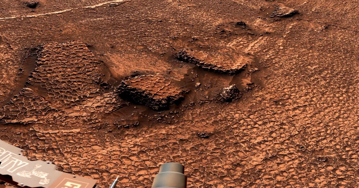
NASA’s Curiosity rover has delivered a striking new dataset from Mars: an extensive field of polygonal fractures—honeycomb-like patterns roughly two to four inches across—mapped in the Valle Grande region near the foothills of Mount Sharp (Aeolis Mons). Built from 340 Mastcam images captured on June 19, the panorama is notable not merely for its visual clarity, but for the scale and continuity of the polygonal terrain. On Earth, similar textures often point to mud-crack desiccation in drying sediments or thermal contraction in cold, brittle materials—two pathways that imply very different environmental histories, yet both intersect with the central question of Martian exploration: where and how water once shaped the planet’s surface.
For planetary scientists, polygonal fracture networks are rarely “just patterns.” They are physical records of stress, chemistry, and time—etched into rock as environmental conditions oscillate. The Valle Grande polygons, appearing in an unusually broad and coherent field, offer a fresh opportunity to test competing hypotheses about ancient hydrology, climate cycling, and the persistence of potentially habitable microenvironments.
Key attributes that elevate this find beyond routine rover imaging include:
- Unprecedented extent of polygonal features within a single mapped zone, strengthening statistical confidence in formation models
- Consistent geometry and spacing, which can encode the mechanics of drying, freezing, or mineral shrinkage
- Strategic location on Mount Sharp’s lower slopes, where Curiosity has been reading Mars’s layered history like a stratigraphic ledger
From pixels to provenance: how Curiosity turns imagery into geologic evidence
Curiosity’s value proposition has always been its ability to combine context imaging with in situ chemistry, converting a compelling landscape into a defensible scientific narrative. The Mastcam system’s ability to stitch high-resolution panoramas across three spectral bands provides more than a postcard; it enables repeatable terrain mapping, measurement of fracture dimensions, and identification of subtle tonal differences that may correlate with mineralogy.
Just as important is the modern analytical workflow behind the scenes. Large image sets are increasingly triaged through automated detection and classification, allowing teams to flag candidate polygon fields quickly and allocate scarce rover time to the most diagnostic targets. This is not simply operational efficiency; it changes the tempo of discovery by reducing the lag between observation and hypothesis testing.
The next step is verification—determining what the fractures are *made of* and what that implies about their origin. Curiosity’s instrument suite is designed for precisely this kind of forensic geology:
- APXS (Alpha Particle X-Ray Spectrometer) can quantify elemental composition, helping distinguish clay-rich mudstones from other sedimentary matrices
- ChemCam can interrogate targets remotely with laser-induced breakdown spectroscopy, rapidly screening for silica enrichment, salts, or other signatures consistent with evaporation or alteration
- Combined with Mastcam context, these tools can test whether the polygons reflect desiccation in once-wet sediments, freeze-thaw or thermal contraction, or even diagenetic processes where minerals precipitate and shrink as fluids move through rock
This is where the discovery becomes more than a curiosity: polygon fields can act as environmental boundary markers, pointing to episodes when Mars shifted between wetter and drier regimes—or between warmer and colder ones—with implications for how long surface or near-surface water may have persisted.
Water cycles, climate signals, and the habitability question embedded in the cracks
Polygonal fracturing is a deceptively compact clue with outsized interpretive power. If the Valle Grande features are classic mud cracks, they imply episodic wetting and drying—conditions consistent with transient lakes, shallow pools, or saturated sediments exposed to aridification. If thermal contraction dominates, the polygons may reflect cold-climate stress, potentially tied to longer-term cooling, seasonal extremes, or freeze-thaw dynamics.
Either pathway points to environmental cycling, not a static Mars. That matters because habitability is rarely about a single moment of water presence; it is about duration, recurrence, and chemical gradients—the ingredients that can sustain energy sources and preserve biosignatures.
From an astrobiology perspective, polygon-forming environments can create localized niches where chemistry concentrates:
- Evaporative settings can trap salts and organics, sometimes improving preservation potential
- Clay-bearing sediments can protect complex molecules from radiation and oxidation
- Repeated wet-dry cycles can drive chemical reactions relevant to prebiotic pathways, even if life never emerged
The scientific agenda now becomes sharply practical: characterize polygon morphology, map transitions across the field, and determine whether the fractures cut through uniform material or track compositional boundaries. Each answer tightens constraints on Mars’s paleoclimate reconstruction and helps prioritize where future missions should drill, cache, or return samples.
The business and policy ripple effects: why a geologic pattern can move markets
High-profile discoveries like this do more than advance planetary science; they reinforce the strategic logic of sustained investment in space-grade sensing, autonomy, and advanced materials. Curiosity’s imaging and navigation heritage continues to seed terrestrial applications—particularly in industries where operations are remote, hazardous, or data-intensive.
Business and technology leaders should read this moment as a case study in how exploration R&D becomes economic infrastructure:
- Technology spillovers: rover-derived imaging pipelines and autonomy methods increasingly inform precision mining, pipeline inspection, and environmental monitoring
- AI-driven science as a platform: machine learning models trained on Martian terrain classification are being repurposed for Earth systems such as agriculture analytics and permafrost mapping, underscoring bidirectional value
- Supply chain strategy: the dependence on radiation-hardened electronics and specialized composites highlights both fragility and opportunity—fueling interest in domestic manufacturing capacity and resilient procurement
At the policy level, discoveries that capture public attention can translate into political durability for large programs—from Mars Sample Return planning to broader exploration architectures. They also shape international positioning: as China and Europe expand planetary ambitions, NASA’s ability to extract new science from long-lived assets like Curiosity reinforces U.S. leadership while setting the tone for collaboration, data standards, and potential sample-sharing frameworks.
For the Mars roadmap, the Valle Grande polygons are not merely a scenic anomaly. They are a navigational beacon—scientifically and strategically—pointing toward the kinds of sites where hydrated minerals, water-related alteration, and preservation potential may converge. In planetary exploration, the most valuable terrain is the terrain that can still answer questions—and these fractures look like Mars offering another page of its history, written in a geometry that demands to be read.

 By
By

 By
By
 By
By

 By
By
 By
By