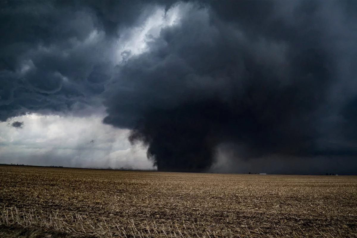


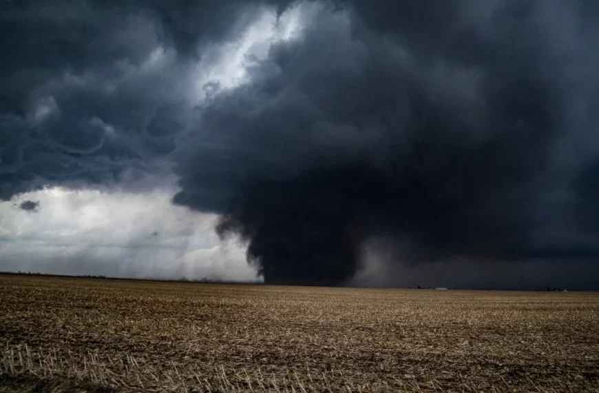
Illinois’ tornado surge redraws the U.S. severe-weather map—and the risk ledger
From January through June 21, 2026, Illinois recorded 196 confirmed tornadoes, outpacing every other state over a comparable period since 2015 and surpassing long-associated Tornado Alley leaders such as Kansas and Oklahoma. Indiana (70) and Wisconsin (45) followed, reinforcing a pattern meteorologists have been tracking for years: tornado activity is increasingly concentrating east of the traditional Great Plains core, into the Midwest and parts of the Southeast.
The emerging narrative is not simply “more tornadoes,” but tornadoes in different places—and that distinction matters. Communities, insurers, utilities, and manufacturers have historically calibrated preparedness, building standards, and capital planning around a relatively stable hazard geography. When the geography shifts, legacy assumptions become liabilities.
Meteorological analyses cited in the latest assessments point to a changing atmospheric setup: drought conditions in portions of the Great Plains can reduce storm “fuel,” while the Mississippi and Ohio Valleys see more frequent combinations of low-level moisture, warmth, and wind shear—ingredients that can support severe convective storms. Experts remain careful not to attribute the rising counts directly to climate change in a simplistic, one-to-one way. Yet the operational takeaway for business and government is the same: risk is migrating, and preparedness must migrate with it.
—
The technology stack behind faster warnings: IoT sensors, edge AI, and regional retraining
As tornado corridors expand, the most immediate technology implication is the need to scale detection and alerting beyond traditional hotspots. The warning ecosystem—radar coverage, local sensors, alert distribution, and decision automation—was not uniformly designed for a world where Illinois becomes the headline.
Key technology vectors now moving from “nice-to-have” to “critical infrastructure” include:
- Distributed sensor networks and localized radar augmentation
Deploying low-power Doppler radar nodes, IoT-enabled anemometers, and dense telemetry grids can improve detection of fast-evolving storm rotation, especially in areas where terrain, distance, or coverage gaps reduce fidelity. This is a natural arena for public-private partnerships, because the benefits span public safety, grid reliability, and commercial continuity.
- Edge computing for sub-five-minute operational alerts
Tornado lead times are often measured in minutes. Edge processing—closer to the sensor and the end user—can reduce latency and enable automated actions: pausing industrial processes, triggering facility lockdown protocols, or routing logistics fleets away from impact zones.
- AI/ML model retraining for new microclimates
A shift into humid continental and mixed-humid climates changes storm behavior, data distributions, and false-positive/false-negative tradeoffs. AI systems built on historical Plains-centric patterns may require region-specific retraining, integrating local land use, boundary-layer moisture profiles, and storm-mode differences.
In practical terms, the eastward shift turns severe-weather forecasting into a data engineering challenge as much as a meteorological one: more sensors, more heterogeneous streams, and more demand for real-time inference that can be trusted by emergency managers and enterprise operators alike.
—
Digital twins meet catastrophe finance: how insurers, utilities, and cities may reprice the Midwest
The economic signal embedded in Illinois’ 2026 tornado count is not confined to property damage; it extends into insurance pricing, capital markets, and municipal finance. If tornado frequency and exposure rise in states previously treated as comparatively lower risk, the market response is likely to be swift—and uneven.
Insurance and reinsurance are poised to be the first major transmission mechanism:
- Underwriting recalibration in inland states could drive premium repricing, coverage tightening, and higher deductibles, particularly for commercial properties with large roof spans, older construction, or limited shelter infrastructure.
- Capital strain may accelerate the adoption of parametric insurance—contracts that pay out when measurable thresholds (e.g., wind speed) are breached—reducing claims friction and speeding liquidity after events.
- The search for diversified risk transfer may expand catastrophe bonds and other insurance-linked securities tied to inland wind risk, not just coastal hurricane exposure.
At the same time, the technology enabling better forecasting is also enabling more granular financial modeling. Digital twin frameworks—combining topography, building footprints, infrastructure networks, and live weather telemetry—can run ensemble scenarios that estimate outage cascades, structural vulnerability, and recovery timelines. For:
- Utilities, this supports real-time stress tests on substations, transmission corridors, and vegetation management priorities.
- Municipal authorities, it informs shelter placement, siren coverage, and building-code modernization.
- Insurers and reinsurers, it strengthens portfolio-level risk selection and pricing discipline.
Underneath it all sits a compute reality: next-generation severe-weather modeling increasingly depends on cloud-native high-performance computing (HPC) to scale simulations quickly enough to be operationally relevant, not merely academically interesting.
—
What business leaders should do now: site selection, supply chains, and resilience as strategy
For executives, the most consequential shift is organizational: tornado risk can no longer be treated as a background variable reserved for facilities teams. In parts of the Midwest and adjacent regions, it is becoming a board-level enterprise risk management input—with direct implications for expansion, M&A, and operational continuity.
Priority actions emerging from the 2026 pattern include:
- Risk-adjusted growth and location analytics
Site selection models should incorporate dynamic severe-weather layers, not static historical averages. Expansion decisions in southern Illinois, Indiana, and nearby corridors increasingly warrant stress tests against updated tornado probabilities, shelter access, and local emergency-management capacity.
- Supply-chain redesign for rapid disruption
Tornadoes can disable distribution hubs, sever power, and block transport routes with little notice. Manufacturers and logistics providers may need:
– dual-sourcing agreements for critical inputs,
– relocated spare-parts depots, and
– shared rapid-response stockpiles and mobile command capabilities through cross-industry coalitions.
- Infrastructure hardening as competitive differentiation
Co-investments with state and local governments—microgrids, hardened cell towers, resilient roads, and storm-ready public facilities—can reduce downtime while strengthening community resilience. Companies that engage early in regulatory proceedings and FEMA-aligned planning may also position themselves for tax incentives and prioritized recovery funding.
The broader lesson from Illinois’ unprecedented early-2026 tornado count is that severe-weather risk is becoming a dynamic frontier—one that reshapes technology roadmaps, insurance economics, and the logic of where and how businesses operate. Organizations that treat atmospheric volatility as a strategic planning input—measured, modeled, and operationalized—will be better positioned to protect people and assets while competing in a Midwest economy where resilience is rapidly becoming a core capability.
 By
By
 By
By
 By
By
 By
By
 By
By
 By
By

 By
By