
When a consumer GPS route collides with critical urban rail infrastructure
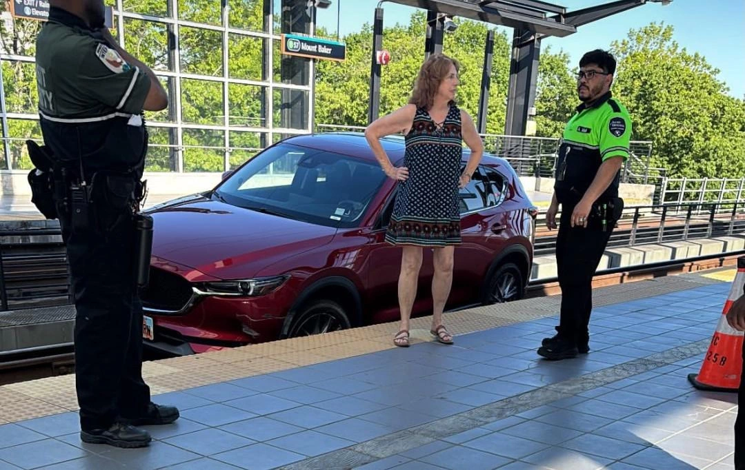
Seattle’s recent light-rail disruption—triggered when a 70-year-old driver followed GPS directions onto an elevated track for roughly a quarter mile—reads like a viral-age oddity. Yet the operational reality was decidedly material: the city’s 1 Line service was halted for two hours, specialized crews were mobilized, and a vehicle had to be lifted off the rails. Authorities reported no intoxication and no injuries, but the incident still exposes a recurring tension in modern mobility: navigation systems are increasingly treated as authoritative, even when the environment is complex, layered, and unforgiving.
For business and technology leaders, the episode is less about individual error than about system design under real-world constraints. Elevated guideways, multi-level interchanges, dense downtown corridors, and mixed-use rights-of-way create “edge cases” where a routing instruction can become ambiguous—or dangerously wrong—without additional context. As cities invest in rail, bus rapid transit, and protected corridors, the cost of a single misnavigation event rises: not only in delays, but in public confidence and operational resilience.
The technical fault lines: geospatial integrity, interface design, and overtrust
At the heart of incidents like this is geospatial data integrity—the accuracy and classification of what is drivable, what is restricted, and what is physically reachable. GPS positioning can degrade in “urban canyon” conditions, near reflective surfaces, and around elevated structures. But the more subtle risk lies in the mapping layer itself: if a pathway is misclassified, poorly updated, or insufficiently tagged as non-vehicular, a routing engine may produce a plausible-but-wrong instruction.
Equally consequential is human-machine interaction. Navigation tools have trained users to expect deterministic correctness: a calm voice, a clean line on a map, a confident “turn now.” Over time, that confidence can erode situational vigilance—especially when drivers are stressed, unfamiliar with the area, or operating under cognitive load. The Seattle incident underscores a design gap: many consumer navigation interfaces still lack robust “are you sure?” friction when a route approaches non-road surfaces or restricted infrastructure.
Several technical directions stand out as both feasible and commercially relevant:
- Sensor fusion beyond GPS: Combining GPS with camera-based scene understanding, LiDAR-derived point clouds (where available), inertial measurement, and high-definition map constraints can reduce reliance on any single signal.
- Infrastructure-aware digital twins: Cities and transit operators increasingly maintain detailed models of rail corridors and stations. Integrating these into routing validation could help systems recognize “this is a guideway, not a road.”
- Low-latency cross-validation: With edge computing and 5G, navigation platforms can more quickly reconcile device location, map constraints, and live hazard reports—shrinking the window where a driver proceeds down an invalid path.
The strategic takeaway is clear: routing is no longer just a consumer convenience feature. It is a safety-critical decision engine operating in environments where mistakes can halt public infrastructure.
The hidden balance sheet: disruption costs, liability exposure, and insurance repricing
A two-hour suspension on a major urban line is not merely an inconvenience; it is an economic event. Transit interruptions ripple outward into missed connections, delayed shifts, reduced retail foot traffic near stations, and reputational damage for agencies already under pressure to deliver reliable service. Add the direct costs—emergency response coordination, specialized equipment deployment, and staff overtime—and the incident becomes a case study in how small navigation failures can create outsized operational liabilities.
The legal and insurance dimensions are equally instructive. When misnavigation intersects with restricted infrastructure, stakeholders can include:
- Mapping and navigation vendors, if route guidance or map classification is alleged to be defective
- Device manufacturers and automotive OEMs, if in-vehicle systems failed to warn or constrain routing
- Municipalities and transit authorities, if signage, barriers, or geofencing measures are argued to be insufficient
Even when litigation does not materialize, insurers pay attention to patterns. For fleets—delivery, service vehicles, paratransit—heavy reliance on consumer-grade navigation may prompt premium repricing or push adoption toward enterprise navigation with redundancy, auditability, and policy controls. In that sense, incidents like Seattle’s can accelerate a market shift: safety features become insurable features, and insurable features become procurement requirements.
A roadmap for stakeholders: from reactive recovery to proactive mobility safety nets
The most productive response is not to demand perfect drivers or perfect maps, but to build shared safeguards across the mobility stack. The Seattle episode points to practical moves that align public safety with commercial incentives:
- Dynamic, near-real-time map updates: Navigation providers can expand from periodic updates to telemetry-driven detection of anomalies—flagging “no-go” zones quickly when unusual incursions occur.
- Public-private “authoritative layers”: Transit agencies can provide certified infrastructure data—guideway boundaries, access points, restricted areas—so routing engines can treat them as hard constraints, not soft suggestions.
- Proactive geofencing APIs: Standardized interfaces that broadcast restrictions and hazards across platforms could allow automatic route exclusion, rather than relying on users to notice a wrong turn.
- Context-aware in-vehicle alerts: Automotive OEMs and Tier-1 suppliers can enhance driver-assistance displays with warnings when the planned route conflicts with onboard metadata—recognizing patterns like rail ties, platform edges, or pedestrian-only surfaces.
The broader industry context makes these steps more urgent. As ADAS adoption rises, even “manual” driving becomes software-mediated, and public expectations shift toward systems that prevent obvious misroutes. Meanwhile, cities pursuing smart infrastructure and V2I communication are effectively building the foundations for a digital safety net—one that can detect, warn, and eventually intervene before a vehicle enters a protected corridor.
Seattle’s light-rail disruption may be remembered online as an improbable detour, but for mobility strategists it reads as a signal: the next phase of navigation is not about faster ETAs—it is about verifiable constraints, shared infrastructure intelligence, and interfaces that earn trust by knowing when not to be followed.

 By
By
 By
By
 By
By
 By
By


 By
By