

A newly unified under-ice province reshapes what we know about East Antarctica’s stability
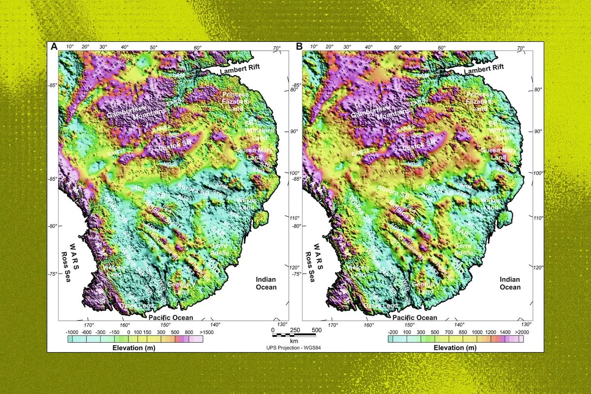
A major reframing is underway in Antarctic geoscience: researchers have delineated a vast, contiguous subglacial structure roughly two miles beneath East Antarctica’s ice, now described as the East Antarctic Fan-shaped Basin Province. Rather than treating the Wilkes Basin, Aurora Basin, and Lake Vostok as largely separate features, the new interpretation connects them into a single, province-scale geological system formed through “distributed rotational extension”—a long-term tectonic process that can thin and reconfigure crust across enormous areas.
For climate science and coastal economies alike, the significance is not academic. This province underpins roughly half of the East Antarctic Ice Sheet, meaning its geometry and physical properties are likely to influence:
- Ice-sheet flow pathways (how quickly ice can move toward the ocean)
- Basal hydrology (where meltwater collects, drains, and lubricates the ice-bed interface)
- Sensitivity to warming (how the system responds as ocean and atmospheric conditions evolve)
In practical terms, the discovery adds resolution to a question with direct financial consequences: how stable is East Antarctica over multi-decadal to century timescales, and what does that imply for future sea-level rise and the distribution of coastal risk?
From gravity and magnetics to “digital geology”: the technology stack behind the discovery
The province-scale mapping reflects a broader shift in Earth observation: subsurface understanding is increasingly a data-fusion problem, where multiple sensing modalities are integrated into coherent models. The study’s approach—combining gravity and magnetic surveys, crustal-structure models, and direct geological observations—highlights a maturing toolkit that is moving from specialized research into scalable platforms.
Several technology vectors stand out:
- Advanced geophysical sensing and survey automation
– Satellite gravimetry and airborne magnetics are becoming more interoperable with high-resolution seismic and radar products.
– This convergence is likely to expand demand for next-generation sensors, autonomous aerial platforms, and real-time data fusion pipelines capable of operating in extreme environments.
- Big-data modeling, inversion, and AI-assisted interpretation
– Reconstructing millions of years of crustal deformation requires high-performance computing and increasingly machine-learning–driven inversion—methods that infer subsurface structure from indirect measurements.
– The commercial opportunity is not limited to academia: it points toward cloud-based simulation services, digital-twin frameworks for Earth systems, and proprietary geoscience algorithms that can be repurposed across energy, infrastructure, and climate analytics.
- Extreme-environment robotics and materials engineering
– Any move toward deeper validation—drilling or in situ measurement beneath ~2,000 meters of ice—demands low-temperature electronics, high-pressure housings, novel antifreeze fluids, and robust autonomy.
– These innovations have clear spillover potential into deep-sea exploration, subsea infrastructure inspection, and even aerospace-grade materials and power systems, where reliability under harsh constraints is a shared requirement.
The broader narrative is that Antarctic science is increasingly a proving ground for dual-use sensing, autonomy, and compute-intensive modeling—capabilities that can migrate quickly into commercial and strategic domains.
Why markets and insurers will care: translating subglacial structure into coastal risk pricing
For business leaders, the most immediate relevance lies in how improved subglacial mapping can tighten the uncertainty bands around sea-level rise projections. Insurers and reinsurers already price coastal exposure using probabilistic models; what changes with better Antarctic boundary conditions is the shape of the tail risk—the low-probability, high-impact outcomes that drive capital reserves and catastrophe-linked instruments.
Expect knock-on effects across:
- Climate-risk assessment and insurance underwriting
– More accurate representations of ice-bed dynamics can refine loss-probability curves for coastal real estate, municipal infrastructure, and critical facilities.
– This can influence pricing for catastrophe bonds, reinsurance treaties, and long-duration asset portfolios exposed to coastal flooding.
- Infrastructure, ports, and long-horizon capital allocation
– Ports, logistics hubs, and coastal utilities operate on multi-decade investment cycles. Updated Antarctic science can change the calculus for:
– Resilience retrofits
– Siting decisions
– Insurance coverage structures
– Green and resilience bond issuance tied to adaptation performance
- Resource governance and prospectivity—despite the moratorium
– The Antarctic Treaty system currently suspends mineral extraction, but the moratorium’s review horizon (often discussed in relation to 2048) means that geostructural roadmaps can still shape long-term positioning.
– Even absent extraction, better geological understanding can affect future debates around strategic minerals and freshwater reserves, and it may influence how “Observer” states and consortia prioritize scientific presence and capability-building.
In effect, the discovery is not just a scientific consolidation; it is a risk-information upgrade that can propagate into financial models, disclosure regimes, and infrastructure strategy.
Polar science as strategic capital: governance, dual-use capabilities, and climate diplomacy
Antarctica is also a geopolitical arena where scientific capacity functions as a form of influence. As major powers expand research operations, discoveries of this magnitude can become reference points in debates over environmental protocols, station placement, and future governance frameworks.
Three strategic dynamics are likely to intensify:
- Treaty politics and scientific footprint
– As the mineral-extraction moratorium approaches its longer-term review window, states may seek to strengthen their negotiating position through expanded scientific programs and data leadership.
- Dual-use technology pathways
– Sub-ice mapping, autonomous vehicles, and extreme-environment communications can translate into capabilities relevant to Arctic security, undersea cable monitoring, and polar logistics—areas where defense contractors and national labs often collaborate with civilian science.
- Climate diplomacy and carbon-market credibility
– Improved projections of Antarctic mass balance will inform Nationally Determined Contributions (NDCs) and corporate transition-risk disclosures.
– Companies with heavy coastal footprints will increasingly demand transparent, science-based forecasts that can withstand regulatory scrutiny and investor due diligence.
The East Antarctic Fan-shaped Basin Province is, at its core, a reminder that the planet’s most consequential economic variables—coastal risk, infrastructure resilience, and climate liability—can hinge on structures hidden miles beneath ice. As sensing, AI-driven modeling, and polar robotics advance in tandem, the competitive edge will accrue to organizations that treat Antarctic science not as distant curiosity, but as actionable intelligence shaping capital, governance, and long-term strategy.

 By
By
 By
By
 By
By
 By
By
 By
By
 By
By